
Our Location and Directions
 Bible Baptist Church of Oak Harbor is
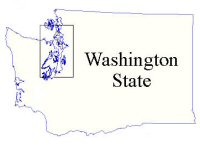
located on beautiful Whidbey Island in the Northwest corner of Washington State.
Its facilities are located three miles south of Oak Harbor (six miles north of
Coupeville) on State Route 20 near Hastie Lake. The Church parking lot is entered
from Harns Road.
Bible Baptist Church of Oak Harbor is
located on beautiful Whidbey Island in the Northwest corner of Washington State.
Its facilities are located three miles south of Oak Harbor (six miles north of
Coupeville) on State Route 20 near Hastie Lake. The Church parking lot is entered
from Harns Road.
Officially the longest island in the continental United States, Whidbey Island sits nestled among the islands of Puget Sound with a spectacular view of the Olympic Mountains to the SW, and Mount Baker and the Cascades to the NE and east. It is reached from the north end by bridges across the breath-taking Deception Pass, and from the south end by the Clinton–Mukilteo ferry.
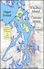 As the crow flies (on a straight line), Oak Harbor is located about 50 miles NNW of Seattle
(95 road miles, or 1¾ hours to drive), and about 50 miles south of the US–Canada border (75 road miles,
or 1½ hours to drive). To the northwest lie the San Juan Islands, a very popular tourist area and favorite site for Orcas
(“killer whale”) watching. Thirty-five miles to the west is the southern tip of Vancouver Island, British Columbia
and its capital city, Victoria.
As the crow flies (on a straight line), Oak Harbor is located about 50 miles NNW of Seattle
(95 road miles, or 1¾ hours to drive), and about 50 miles south of the US–Canada border (75 road miles,
or 1½ hours to drive). To the northwest lie the San Juan Islands, a very popular tourist area and favorite site for Orcas
(“killer whale”) watching. Thirty-five miles to the west is the southern tip of Vancouver Island, British Columbia
and its capital city, Victoria.
Directions
To get to Bible Baptist Church, use the following directions:
BY CAR:
This is the most common way of getting to us, although one must first go north to go south. Allow at least 45 minutes to drive this route. Highway 20 is mostly two-lane highway, with speed limits no higher that 55 mph.
- Take I-5 North.
- Take Exit 230 at Burlington.
- Turn left onto SR-20 and head back under interstate (west). (Our Church premises are actually located on SR-20, but you will need to take the following directions from Burlington:)
- Take SR-20 west for 11.9 miles.
- Soon after the refineries on the right, SR-20 West will turn south.
- Turn left at the traffic signals.
- Take SR-20 for 16.4 miles into Oak Harbor.
- Just past the Safeway/Rite Aid shopping center, SR-20 turns right.
- Turn right at the traffic signals and stay on SR-20 out of town for 3.5 miles.
- Just after Hastie Lake Road, around the next bend, you will see our Church sign.
- Enter the parking lot by turning right onto Harns Road.
BY CAR & FERRY:
Ferry schedules vary according to the time of the year. To check
schedules and fares, log onto http://www.wsdot.wa.gov/ferries/
From the Mainland: Whidbey Island can also be accessed from the mainland by the Washington State Ferry system.
- Take SR-525 from I-5 in Everett, traveling west to Mukilteo.
- Take the Clinton ferry from the terminal at the end of the Mukilteo Speedway. (The ferry takes about 20 minutes, and fares apply to driver & vehicle and each passenger.)
- Take SR-525 north for 22 miles.
- SR-525 then becomes SR-20.
- Continue north on SR-20 for 11.4 miles
- The church premises are quite visible on the left hand side of SR-20.
- Enter the parking lot by turning left onto Harns Road.
Once you are off the ferry, it will take about one hour to drive up the island to the Church. The route is mostly a two-lane highway, with speed limits no higher than 55 mph.
From the Olympic Peninsula:
- Catch the Keystone–Port Townsend ferry at the Port Townsend Ferry Terminal.
- The ferry takes about an hour to cross.
- After coming off the ferry, go left and follow the traffic away from the ferry terminal. The road will take you toward Coupeville and SR-20.
- Turn left onto SR-20 and travel north for 6 miles.
- The church premises are quite visible on the left hand side of SR-20.
- Enter the parking lot by turning left onto Harns Road.
Once you are off the ferry, it will take about 15 minutes to drive to the Church.